Contour Levels - Grid Editor
The Contour Levels dialog controls the Advanced contours in the Grid Editor. Click the Edit Levels button in the Contours page to open the Contour Levels dialog.
|
|
|
The Contour Levels dialog controls the display of the contour map in the grid editor window. |
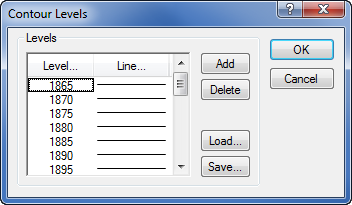
Levels Group
The Levels group lists the contour levels and colors of contour lines used in the grid editor window.
Levels
Click the Level button to display the Contour Levels dialog. The Contour Levels dialog controls the minimum and maximum contour levels as well as the contour interval to use between levels.
Line
The Line button displays the Line Spectrum dialog that controls the colors and widths of the minimum and maximum contour lines. Surfer automatically produces a gradational spectrum of colors between the minimum and maximum colors.
Add
The Add button adds a contour line halfway between selected contour level and the next lower contour. If the minimum contour level is selected, the added contour level is the same as the minimum level.
Delete
The Delete button removes the selected contour from the list of contours.
Load
The Load button allows you to select an existing level file [.LVL] containing contour level information. All grid files using the level file must have comparable Z data ranges, otherwise contour lines will not appear on the map.
Save
The Save button allows you to save the current contour level and line property information to a level file .LVL.