Info Properties - Objects
The Info properties page contains information about the selected object. Info properties are available with drawn objects, such as polylines, polygons, points, grouped objects, images, and metafiles, with map objects, axes, and map layers, such as contours or base layers. The information displayed is dependent on the type of object, and the image below is just one example of an Info properties page.
The Info page is located in the Properties window for the selected object. A single object must be selected to display the Info page.
Note: Grid layers have their own Info properties page.
|
|
|
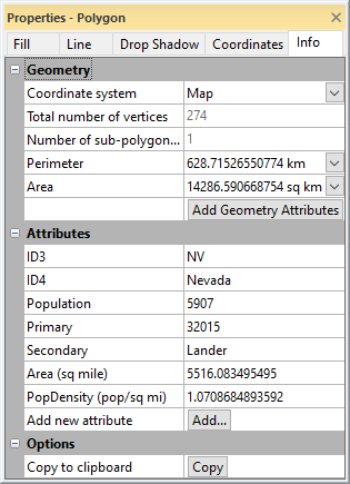
The Info page displays information for the selected object. |
Geometry Section
The Geometry section includes properties that specify the Coordinate system for calculating the geometry values and display the perimeter, length, position, or area of the selected object. Click on the ![]() next to Geometry to open the section. This section is only available for polylines, polygons, symbols, rectangles, rounded rectangles, ellipses, or spline polylines.
next to Geometry to open the section. This section is only available for polylines, polygons, symbols, rectangles, rounded rectangles, ellipses, or spline polylines.
Select the units for the units for the Perimeter, Area, Length, or Position values by clicking the value and selecting the desired units from the list. The selected units are moved to the top of the list, otherwise the units are displayed alphabetically.
Coordinate System
Specify a coordinate system from the Coordinate system list to be used for the information displayed for the object.
- Page uses the page coordinate system (inches or centimeters depending on the setting in the Options dialog General page).
- Local uses the units from the layer in which the geometry was originally specified. For example, if the geometry was loaded from a file, this is the original file units. If the geometry was created interactively, this is an internal coordinate system with 0.0 in the center of the page (in inches).
- Map displays information in map units if the geometry is part of a map. If the object is not part of a map, this option is not available.
The default Coordinate system property is Map for map objects and Page for objects outside a map. Changes to the Coordinate system selection are applied to all objects. For example, if the property is changed to Local for one object, the Local information will be displayed for the next selected object. If the selected Coordinate system is a geographic coordinate system, i.e. uses spherical coordinates, some geometry information cannot be displayed.
Position
This displays the XY position of a point, for example in a base (vector) map.
Total Number of Vertices
The Total number of vertices displays how many vertices are used in the selected object. The Reshape command can be used to see the vertex locations for polygons and polylines.
Number of Sub-Polygons
If the object contains a complex polygon, the Number of sub-polygons (rings) displays how many polygons are included in the complex polygon. For example, the sample file ca2010.gsb has polygons of California counties. Some of the counties are complex polygons (i.e. Santa Barbara) that include sub-polygon islands.
Number of Curves
The Number of curves is displayed for a spline polyline. The Number of curves is the number of inflection points along the spline polyline. This is one less than the total number of vertices.
Perimeter/Length
Depending on the object selected, either Perimeter or Length will be displayed.
- The Perimeter displays the calculated perimeter of the selected closed object (i.e. polygon).
- The Length displays the calculated length of the selected open object (i.e. polyline). The units displayed are dependent on what is selected for the Coordinate system.
The Perimeter or Length is not displayed in spherical coordinates (i.e. degrees for Unprojected Lat/Long coordinate systems). If your map is in a geographic coordinate system, change the Target Coordinate System to a projected coordinate system to view the Perimeter or Length. Then specify Map in the Coordinate system field on the Info page.
Area
The Area displays the calculated area of the selected object. The units displayed are dependent on what is selected for the Coordinate system.
The Area is not displayed in spherical coordinates (i.e. degrees squared for Unprojected Lat/Long coordinate systems). If your map is in a geographic coordinate system, change the Target Coordinate System to a projected coordinate system to view the Area. Then specify Map in the Coordinate system list on the Info page.
Add Geometry Attributes
Click the Add Geometry Attributes command to add the geometry values displayed above to the object's attributes. If you wish to add the geometry attributes to all objects in the base layer, use the Attribute Table.
When geometry attributes are added to an object not belonging to a base layer, geometry attributes will be added for all objects of the same type. These attributes cannot be edited or removed for non-base layer objects.
Info Section
The Info section allows you to view the Type, Description, Number of records, size in bytes, Objects in group and image information for the selected object. Click on the ![]() next to Info to open the section. This section is available for text, images, metafiles, grouped objects, and point cloud layers.
next to Info to open the section. This section is available for text, images, metafiles, grouped objects, and point cloud layers.
Type
The Type displays the type of metafile being displayed.
Description
The Description displays any information about the metafile.
Number of Records
The Number of records displays the number of objects in the metafile.
Pixel Format
The Pixel format option displays the type of image imported, including the number of bits per pixel included in the image.
Size in Bytes
The Size in bytes or the Size (bytes) option displays the file size of the image or metafile in bytes.
Size in Pixels
The Size (pixels) option displays the number of pixels in the image.
Image Source
The Image source displays the name of the file imported for an image.
Number of Points
The Number of points displays the number of points in the point cloud layer.
Extents
The xMin, xMax , yMin , yMax, Zmin, and Zmax values display the extents of the point cloud layer.
Attributes Section
The Attributes section contains any information that is available about the selected object. To open the Attributes section, click the ![]() next to Attributes.
next to Attributes.
Attributes can be image properties, such as TIFF_Compression, or can be information about a specific object that was imported from a file, such as a .DEM, .DXF, or .SHP file. Each object (such as polylines in a base map) can have its own attribute information. The Attributes can also contain user generated information.
Adding Attributes
To add an attribute to the Attribute Table,
- Click on the object to select it.
- In the Properties window, click on the Info page.
- Open the Attributes section by clicking the
 next to Attributes.
 - Click on the Add button next to Add new attribute.
- Type the new attribute name, such as Surveyor's Name, in the Attribute name field of the New Attribute Name dialog.
- Click OK in the New Attribute Name dialog. The new attribute is added to the object displayed on the Info page.
- Click in the value column next to the new attribute name. Type the desired description, such as Thomas Denver.
- Now the new attribute and its value has been added to the object.
To rename or remove an attribute, use the Attribute Table.
Edit Attributes
Edit attribute values by typing the new value into the field next to the attribute name in the Properties window. Edit values for multiple attributes in a base layer with the Attribute Table.
For objects that are not part of a map layer:
-
Click Rename (
 ) to open the New Attribute Name dialog to change the name of the attribute.
-
Click Delete (
 ) to remove the attribute for the selected object.
Options Section
The Options section contains the option to copy the attribute data for a selected object. To open the Options section, click the ![]() next to Options.
next to Options.
Copy Attributes
Click the Copy button next to Copy to clipboard to copy all of the information on the Info page for the selected object to the clipboard. The text can be pasted into Surfer or any other program using the Paste command. All information on the Info page is copied, including the information in the Geometry and Info sections. If the Copy button is not available, no attribute information is available for the selected item.
Exporting Attributes
Attribute information is exported for polygons, polylines, and points to file formats that support metadata. The file type will determine how many attributes are exported. Refer to the specific file type pages for specific information.
Displaying Attributes
Attributes can be added to base maps as labels. Click on the Base map layer object in the Contents window to select the base layer. In the Properties window, click on the Labels tab to turn label display on. Any attribute can be used as a label for polylines, polygons, or symbols on a base map layer.
Information Displayed for Objects
All objects display an Attributes and Options section. The information in the Geometry section changes depending on the object selected.
Polyline
The Info properties for Polylines displays the Coordinate system, Number of vertices, and Length.
Polygon
The Info properties for Polygons displays the Coordinate system, Total number of vertices, Number of sub-polygons (rings), Perimeter, and Area.
Point
The Info properties for Symbols displays the Coordinate system and Position in X and Y units.
Rectangle
The Info properties for Rectangles displays the Coordinate system, Perimeter and Area.
Rounded Rectangle
The Info properties for Rounded Rectangles displays the Coordinate system, Perimeter and Area.
Ellipse
The Info properties for Ellipses displays the Coordinate system, Perimeter and Area.
Spline Polyline
The Info properties for Spline Polylines displays the Coordinate system, Number of curves and Length.
Range Ring
The Info properties for Range Rings displays the Coordinate system, Perimeter, and Area. Note that when Number of rings is greater than one, the Perimeter and Area values are for the largest ring.
Group Objects
The Info page for Group Properties displays the number of Objects in group. Each group object can be selected in the Contents window to display the object info.
Metafile
The Info properties for Metafiles displays the Type of metafile, Description, Number of records, and Size in bytes.
Image
The Info properties for Images displays the Pixel format, Size (pixels), Size (bytes), and Image source.