Export LAS/LAZ
Click Point Cloud | Features | Export LAS/LAZ or the  button to export the points in the point cloud layer to an uncompressed LAS or compressed LAZ LiDAR Binary file.
Export Point Cloud Dialog
The Export Point Cloud dialog is displayed when the Point Cloud | Features | Export LAS/LAZ command is clicked. Specify the output file path and name, format, and tiling options in the Export Point Cloud dialog.
|
|
|
Set the export options in the Export Point Cloud dialog. |
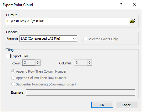
Output
Choose a path and file name for the LiDAR file in the Output section. You can type a path and file name, or click the  button to browse to a new path and enter a file name in the Export Points to File dialog. By default the file name is based on the first file in the point cloud metadata.
Options
Select the Format and whether to export only selected points in the Options section.
Format
Select LAS (Uncompressed LAS File) or LAZ (Compressed LAZ File) in the Format list to export an LAS or LAZ file.
Selected Points Only
Select the Selected points only option to export only selected points in the LAS/LAZ file. Clear the Selected points only check box to export all points in the point cloud layer to the LAS/LAZ file.
Tiling
The Tiling section controls the data tiling options. Tiling is used to limit the size of the exported files. For example, an 11.7 million point layer may be exported to a single 313MB LAS file, or split into nine tiles with file sizes varying between 28 and 45MB.
Export Tiles
Select the Export tiles option to export the point cloud layer as multiple indexed files to reduce file size. The number of tiles is the product of the Rows and Columns values. For example, selecting three (3) rows by three (3) columns leads to nine (9) tiles.
Rows
Specify the number of Rows for tiling the point cloud layer. Type the desired number in the Rows field or click the  to change the value. More Rows means a larger number of smaller files. Fewer Rows leads to a smaller number of larger files.
Columns
Specify the number of Columns for tiling the point cloud layer. Type the desired number in the Columns field or click the to change the value. More Columns leads to a larger number of smaller files. Fewer Rows leads to a smaller number of larger files.
Tile Indexing
The tile file names can be indexed in one of three ways:
- Append row then column number - the row number is appended first and then the column number is appended to the end of the file name in the Output field.
- Append column then row number - the column number is appended first and then the row number is appended to the end of the file name in the Output field.
- Sequential numbering (Row-major order) - the tile in the first row and first column is numbered 0, and then the tiles are numbered in row-major order.
|
|
|
The table above demonstrates the indexing for the tile file names. |
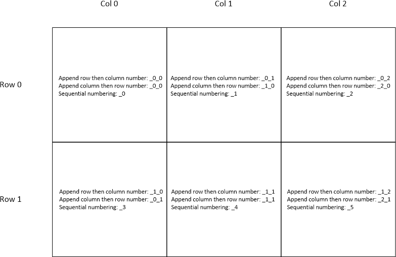
Example
The Example shows an example of the tile file names for the first three tiles in row 0.