Select Bounds Dialog
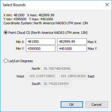
The Select Bounds dialog is displayed when defining the boundary filter in the Import Points dialog or the boundary criteria in the Select by Criteria dialog. The data filtering or selecting bounds can be specified in the Import Points Target Coordinate System or in latitude and longitude degrees.
|
|
|
Filter the data by XY extents with the Select Bounds dialog. |
Input Bounds Information
The complete extents of the input data is displayed at the top of the Select Bounds dialog: X min, X max, Y min, and Y max. The Coordinate System indicates the target coordinate system of the input LAS data in the Import Points dialog.
Point Cloud Coordinate System
Select Point Cloud CS to limit the imported points to, or select the points within, bounds defined in the same coordinate system as the point cloud layer. Type the desired extents in the Min X, Max X, Min Y, and Max Y fields.
Lat/Lon Degrees
Select Lat/Lon Degrees to limit the imported points to, or select the points within, bounds defined in World Geodetic System 1984 latitude and longitude coordinates. Type the desired coordinates in the North, West, East, and South fields.