Source Coordinate System Properties
Maps can be created from data, grids, or base map files in any coordinate system. The Source Coordinate System is the coordinate system for the original data, grid, or base map used to create a map layer. Each map layer can reference a different projection and datum. If some map layers are using a different source coordinate system than what you want the map to display, the map layer is converted to the map's Target Coordinate System.
3D surface maps and wireframe maps do not have an associated coordinate system and cannot be converted to a different coordinate system. When a layer with a coordinate system is overlaid onto either a surface or wireframe map, the layer's coordinate system is removed and the layers are displayed in Cartesian coordinates.
When a surface map or wireframe map is created first, the Map object and Surface layer or the Map object and Wireframe layer are set to an unreferenced coordinate system. Any map layers subsequently added to the Map must be in the same units as the surface or wireframe layer.
When a surface layer or wireframe layer is added to an existing map, the target coordinate system of the existing map must first be set to the same coordinate system as the surface or wireframe map to be added. To determine the coordinate system for the surface or wireframe layer, you may need to create a contour map from the grid file, first. Match the Map coordinate system to this grid file. Then, add the surface map or wireframe map.
When a vector map coordinate system is changed, only the location of the vectors changes. The components of the grids, including the direction of the vectors, are not projected. It is assumed that the grid components are in the map coordinate system units.
The target coordinate system can be applied to the source coordinate system for all unreferenced map layers. The Assign to unreferenced layers operation is located in the Coordinate System page of the Map object properties. For example, you may have overlaid map layers all created from the same unreferenced local system with specific units. You can create a new local coordinate system to define the units for the map, and apply the new system to the map's target coordinate system. Next use Assign to unreferenced layers to assign the custom local coordinate system (the map's target coordinate system) to the source coordinate system for all the map layers simultaneously.
The Coordinate System Page
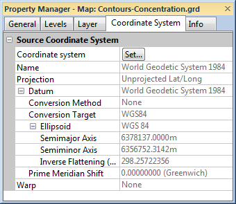
The Coordinate System page is located in the Properties window when a map layer object is selected.
|
|
Specify the map layer coordinate system on the Coordinate System page. |
Coordinate System
Click the Set button next to Coordinate system to open the Assign Coordinate System dialog. This dialog lets you set the source coordinate system. This is the coordinate system for the original data, grid, or base map.
See Also
Map Coordinate System Overview
Introduction to Map Projections