Create a Grid from XYZ Data
The most common application of Surfer is to create a grid-based map from an XYZ data file. An XYZ data file has X data, Y data, and Z data delimited into separate columns (for example, longitude, latitude, and elevation). The Grid Data command uses an XYZ data file to produce a grid file. The grid file is then used by most of the Home | New Map commands to produce maps. Post maps, base maps, point cloud, and drillhole maps do not use grid files.
The general steps to progress from an XYZ data set to a finished grid-based map are as follows:
-
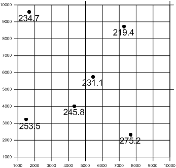
Create an XYZ data file. This file can be created in a Surfer worksheet window or outside of Surfer (using an ASCII text editor or Microsoft Excel, for example).
|
|
|
Start with irregular XYZ data in three columns. |

-
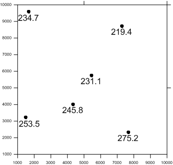
To display the data points, click the Home | New Map | Post command.
|
|
|
A post map displays the original XYZ data locations. |
-
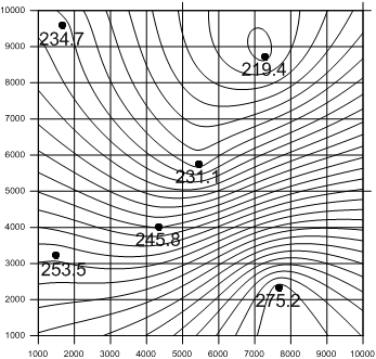
Create a grid file .GRD from the XYZ data file using the Home | Grid Data | Grid Data command.
|
|
|
Gridding interpolates a Z value at the intersection of each row and column in the grid file. This fills the holes in the data. Here the rows and columns are represented by grid lines. |
-
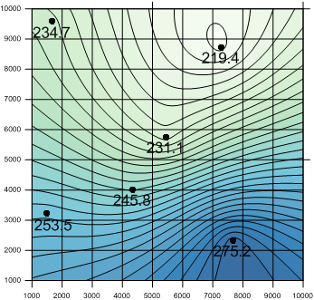
To create a map, select the map type from the Home | New Map commands. Select the grid file from step three. New grid-based maps that can be created include contour, 3D surface, 3D wireframe, color relief, peaks and depressions, 1-grid or 2-grid vector, watershed, and grid values maps.
|
|
|
The post map layer shows the original data points. The contour map layer shows the grid based contour map. |
-
Click on the map to display the map properties in the Properties window where you can customize the map to fit your needs.
|
|
|
The contour map layer is filled with a gradational color fill. |
-
Click the File | Save command to save the project as a Surfer .SRF file which contains all the information needed to recreate the map.