USGS Digital Elevation Model .DEM Export Options Dialog
Use the Grids | Edit | Convert command to save a USGS .DEM file in the plot document. Use the File | Save | Save As command to save a USGS .DEM file in the grid editor.
|
|
|
Customize the DEM options in the DEM Export Options dialog. |
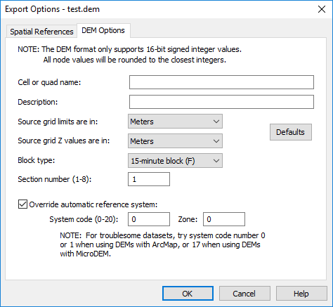
Cell or quad name
Type a name for the DEM image in the Cell or quad name box.
Description
Type a description for the DEM image in the Description box.
Source Grid Limits
Specify the type of units for the XY coordinates in the source grid from the Source grid limits are in list. Click the arrow to display the list. Possible selections are Radians, Feet, Meters, Arcseconds, and Degrees. The export units need to be the same as the map units. For example, if the map units are lat/long, and you choose Meters as the X unit code, then there will be no conversion. If the map is in lat/long, then you have to choose to export as lat/long. You put in what the units of the map are, not what you want the export file to be in.
Source Grid Z Values
Specify the type of units for the Z (vertical) coordinates in the source grid from the Source grid Z values are in list. Click the arrow to display the list. Possible selections are Feet or Meters. The export units need to be the same as the map units. For example, if the map units are lat/long, and you choose Meters as the X unit code, then there will be no conversion. If the map is in lat/long, then you have to choose to export as lat/long. You put in what the units of the map are, not what you want the export file to be in.
Block type
Specify the block type for the DEM image from the Block type list. Click the arrow to display the list.. Possible selections are 15-minute, 7-minute, and Other.
Section Number
Specify the section number by entering a number from one to eight in the Section number (1-8) box. Specify the section number by entering a number from 1 to 8 for a 15-minute block. Specify the section number by entering a number from 1 to 32 for a 7.5-minute block. Ignore the section number for “Other” block types.
Override Automatic Reference System
Select the Override automatic reference system option if you wish to override the automatic reference system code and zone in the DEM file. Clear the Override automatic reference system check box to automatically set the reference system code and zone.
The System code value indicates the projection. The Zone indicates the State Plane or UTM coordinate zone, if applicable. If the DEM exported from Surfer is not read properly by another application, you may wish to override the automatic code. For example, Esri's ArcMap 10 will not read DEMs with System codes greater than 3.
When the Override automatic reference system option is selected, the System code and Zone fields are available. Set the System code to a value between 0 and 20. If the System code is 1 (UTM) or 2 (State Plane), set the Zone to the appropriate coordinate zone number. See the USGS Standards for Digital Elevation Models Part 2, Appendices 2-E, 2-F, and 2-G for more information and a full list of the System code and Zone values.
Standards for Digital Elevation Models
Part 2: Specifications
National Mapping Program
Technical Instructions
U.S. Department of the Interior
U.S. Geological Survey
National Mapping Division
Appendix 2-I
Sectional indicator
The 30-minute DEM's are distributed in groups of files that make up a 30- by 30-minute area of coverage representing the DEM for the east or west half of a 1:100,000-scale source map. The normal distribution group is four 15-minute files per 30-minute area. The quadrangle name field in the header record contains the name of the 1:100,000-scale source map. However, the pieces or sections into which each is divided are identified within the header type A record to the size and placement of each. In byte 138-140 each section is identified by a 3 character code
XNN where:
X is a single letter indicating size
F = 15-minute block
S = 7.5-minute block
NN is a two-digit number indicating the specific quad. Figure 2-I-1 and 2-I-2 illustrate this division with the sections labeled with the code that appears in bytes 138-140 of the header record.
F01 F02 F03 F04
F05 F06 F07 F08
Figure 2-I-1
A 1:100,000-scale quad divided into eight 15-minute quads, 4 per 30-minute area.
S01 S02 S03 S04 S05 S06 S07 S08
S09 S10 S11 S12 S13 S14 S15 S16
S17 S18 S19 S20 S21 S22 S23 S24
S25 S26 S27 S28 S29 S30 S31 S32
Figure 2-I-2
A 1:100,000-scale quad divided into 32 7.5-minute quads, 16 per 30-minute area.'