Graticule
Clicking the Map Tools | Add to Map | Graticule command or the  button adds a graticule to an existing map. A graticule is a network of lines representing the Earth's parallels of latitude and meridians of longitude. A graticule represents lines of latitude and longitude. A map grid represents lines in other units. The Map Tools | Add to Map | Graticule command creates either a graticule or map grid. An existing map or one of its child objects must be selected to enable the Map Tools | Add to Map | Graticule command.
The graticule Units, Origin, Spacing, and Label Format are updated automatically when changing the map target coordinate system.
|
|
|
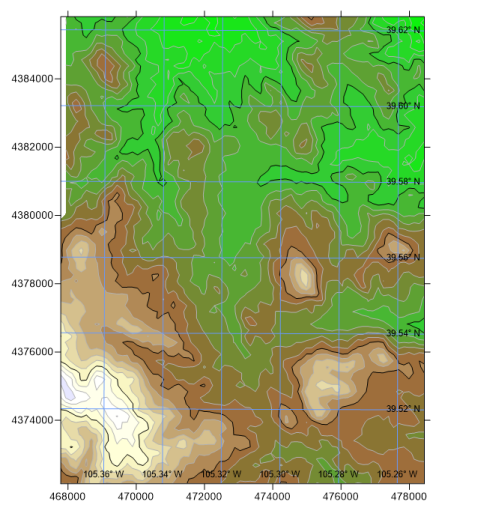
A graticule has been added to this contour map to indicate lat/long coordinates in addition to the coordinate system values displayed on the left and bottom axes. |
To add a graticule to a map:
- In the Contents window or plot window, click on the map to which the graticule should be added.
- Click the Map Tools | Add to Map | Graticule command. Alternatively, right-click the map and select Add | Graticulein the context menu.
- A graticule is added to the map. Select the graticule in the Contents window or plot window to view its properties in the Properties window.
Graticule Properties
The graticule properties are edited in the Properties window. The Properties window contains General, Labels, Layer, and Info pages.
General Page
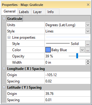
The General page of the Properties window contains options for the graticule units, line style, and spacing.
|
|
|
The General page of the Properties window controls graticule display options. |
Graticule Units
The Units property specifies the units for the graticule. The options in the Units list are dependent on the map coordinate system. If the map is projected, the available options include Degrees (Lat/Long) , Millimeters, Centimeters, Meters, Kilometers, Inches, Feet, Survey Feet, Yards, and Miles. If the map uses a known physical unit, the linear units in the preceding list are available. If the map has a datum, Degrees (Lat/Long) and Unknown map units are available. If the map is unreferenced, only Unknown map units is available. Click the current selection and select a new unit from the Units list to change the graticule units.
Graticule Style
The Style property specifies if Lines or Crosses are displayed to indicate the graticule. Click the current selection and select None, Lines,or Crosses from the list to change the graticule style. The Cross size property is enabled when the Style is set to Crosses. Change the Cross size by typing a value in page units into the Cross size field or clicking the  buttons.
Graticule Line Properties
The Line Properties section controls the display for graticule Lines or Crosses. See the Line Properties help topic for more information on editing line properties. By default, the graticule is created with a Baby Blue line color and 39% opacity.
Graticule Line Origin and Spacing
Graticule lines are drawn at a specified latitude and longitude and equally spaced from the origin. The Longitude ( X ) Spacing section controls the placement and spacing of longitude graticule lines. The Latitude ( Y ) Spacing section controls the placement and spacing of latitude graticule lines.
The Origin property determines the alignment point for the graticule lines. Specify the Origin by typing a value in the Units specified in the Properties windowinto Origin field. The Origin also controls which lines are labeled when the Label Frequency property on the Labels page is a value other than 1. The graticule line at the origin is always labeled.
The Spacing property specifies the distance between the graticule lines. Set the graticule Spacing by typing a value in the Units specified in the Properties window into the Spacing field. The minimum Spacing value is arbitrarily limited so that a maximum of 10000 graticule lines are drawn.