Grid Project
Click the Grids | Edit | Project command or the  button to create a new grid in a different coordinate system from a grid in an existing map layer or a grid file. The Project command creates a grid in the desired coordinate system and then resamples the original grid to populate the new grid with Z values. You can control the output grid coordinate system, geometry, and resampling method. Click the Grids | Edit | Project command to open the Grid Project dialog.
Grid Project Dialog
The Grid Project dialog contains the options for creating the projected grid file.
|
|
|
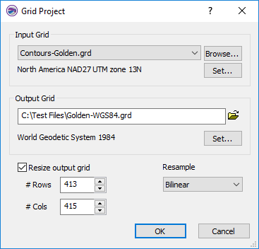
Specify the coordinate system, grid geometry, and resample method in the Grid Project dialog. |
Input Grid
Specify the source map layer or grid file in the Input Grid section. Click the current selection and select a map layer from the list. Only map layers created from grid files are included in the Input Grid list. Click Browse to load a grid file with the Open Grid dialog. Click and drag the corner of the Grid Project dialog to resize the dialog if the entire Input Grid path and file name is not visible.
The input grid file coordinate system will be displayed below the Input Grid File field. The coordinate system will be updated automatically if the map layer is referenced or if the grid file includes a georeference file, such as GSR2. Define the Input Grid coordinate system by clicking Set and defining the coordinate system in the Assign Coordinate System dialog.
Output Grid
Specify a path, name, and file format for the projected grid in the Output Grid section. Type a file path and file name, including the file type extension, in the Output Grid field, or click the ![]() button and specify the path and file name for the grid file in the Save Grid As dialog.
button and specify the path and file name for the grid file in the Save Grid As dialog.
Click and drag the corner of the Grid Project dialog to resize the dialog if the entire Output Grid path and file name is not visible.
Specify the desired coordinate system for the projected grid by clicking Set and defining the coordinate system in the Assign Coordinate System dialog.
Resize Output Grid
By default the Resize output grid check box is not checked. The output grid will be the same size as the input grid. The number of rows and columns will be adjusted if necessary to maintain the same or nearly the same grid spacing as the input grid file. The # Rows and # Cols display the number of rows and columns in the output grid. When Resize output grid is not checked, the # Rows and # Cols values are informational and cannot be changed.
Check the Resize output grid check box to specify the number of rows and columns in the output grid. Type a number in the # Rows field or click the  buttons to select the number of rows. Type a number in the # Cols field or click the buttons to select the number of columns.
Resample
The Resample method determines how the Z values for the output grid are calculated. Define the resampling method by selecting a method in the Resample list. The output grid values can be resampled with the Nearest Neighbor, Bilinear, or Cubic Convolution method.
Nearest Neighbor
The Nearest Neighbor method applies the closest grid node value on the original grid to the grid node value in the new projected grid. When the original grid and the new grid differ in size, more than one original node may be applied to the new grid and some original grid cells may not be applied to the new grid. The Nearest Neighbor method is the fastest resampling method, though it can result in distorted output.
Bilinear Interpolation
The Bilinear Interpolation method uses a weighted average of four nodes in the original grid and applies this to the projected grid node value. The projected grid is smoothed compared to the original grid.
Cubic Convolution
The Cubic Convolution method uses a weighted average of 16 nodes in the original grid and applies this to the new grid node value. The projected grid is smoother than the original grid. This method is best for continuous data. This is the slowest resampling method, but it results in a sharper grid than the Bilinear Interpolation or the Nearest Neighbor methods.
OK and Cancel
Click OK to create the projected grid. Click Cancel to close the Grid Project dialog without creating a grid.