Profile Curvature
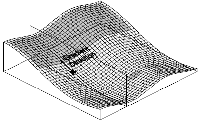
The Grids | Calculate | Calculus terrain model, Profile Curvature, determines the downhill or uphill rate of change in slope in the gradient direction (opposite of slope aspect direction) at each grid node. Grid files of Profile Curvature produce contour maps that show isolines of constant rate of change of steepest slope across the surface. This operation is comparable to the Second Directional Derivative but is more powerful because it automatically determines the downhill direction at each point on the surface, and then determines the rate of change of slope along that direction at that point. Negative values are convex upward and indicate accelerated flow of water over the surface. Positive values are concave upward and indicate slowed flow over the surface.
|
|
|
Profile Curvature measures the curvature of the surface in the direction of gradient. Negative curvature, shown with a gray fill, indicates a convex upward surface and accelerated water flow. |
The profile curvature KPis given by:
|
|

where
|
|
