Terrain Aspect
The Grids | Calculate | Calculus terrain model, Terrain Aspect, calculates the downhill direction of the steepest slope (i.e. dip direction) at each grid node. It is the direction that is perpendicular to the contour lines on the surface, and is exactly opposite the gradient direction. Terrain Aspect values are reported in azimuth, where 0 degrees points due North, and 90 degrees points due East.
|
|
|
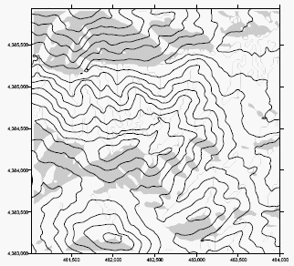
A contour map of the original DEM is layered with a terrain aspect map. South facing slopes (between SE or 135° and SW or 215° ) are indicated with gray fills. Gray lines on north facing slopes are contour fills drawn where the aspect varies between 0 degrees (north) and 359 degrees (1 degree west of north). |
In keeping with the terrain modeling literature, i.e. Moore et al. (1993), Surfer represents the terrain aspect, AT, as an azimuth (in degrees, not radians):
|
|
The compass-based grid notation version of this equation is:
|
|