Vector Map Scaling Properties
To edit a 1-grid vector map or 2-grid vector map, click once on the vector map to select it. The properties for the vector map are displayed in the Properties window. The Scaling page contains placement and sizing options for vector symbols. Each symbol is located at a grid node.
|
|
|
Change vector scaling properties in the Properties window on the Scaling page. |
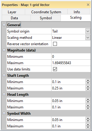
Symbol Origin
The symbol is located on the grid node with the Symbol origin options. To change the Symbol origin, click on the existing option and select a new option from the list. The symbol can be placed at the Tail, at the Center, or at the Head. At the Tail, places the end of the vector symbol on the grid node. At the Head , places the tip of the arrow symbol at the grid node. At the Center places the center of the vector at the grid node.
Scaling Method
There are three ways to scale vectors listed in the Scaling method option. You can scale the symbols between the minimum and maximum data values linearly, logarithmically, or by square root. Linear scaling provides a better visual representation of symbols that, for the most part, are scaled in one dimension (such as arrows with varying shaft length). When scaling the arrows in two dimensions (symbol width and shaft length), Square root or Logarithmic scaling displays the arrows more effectively. To change the Scaling method , click the current option. A list is displayed. Click on the new option and the map automatically updates.
Reverse Vector Orientation
The direction the arrowhead points can be reversed by checking the Reverse vector orientation check box. By default, vectors point in the "downhill" direction. Checking the Reverse vector orientation points the vectors in the "uphill" direction.
Vector Magnitude (data)
Set the Minimum and Maximum data values for the vectors in the Magnitude (data) section. Check the Use data limits box to set the vector minimum and maximum to the grid minimum and maximum values. Setting a new Minimum and Maximum is useful in displaying a series of maps in which you would like all of the vectors to be scaled the same even though the data minimum and maximum may differ.
To set the Minimum or Maximum value, highlight the existing value and type a new value. Values are in Z magnitude units.
Shaft Length
Set the range of the arrow shaft length in the Shaft Length section. The Shaft Length is the length of the arrow symbol from the tip of the tail to the tip of the arrow head. The Minimum value is the smallest shaft length displayed in the map at the Minimum value specified by the Magnitude (data) section. The Maximum value is the longest shaft length displayed in the map at the Maximum value specified by the Magnitude (data) section. Enter a new value into the boxes to change the length. Values are in page units. Values can be between 0 and 10 inches (0 and 25.4 centimeters).
Head Length
Set the range of the head length in the Head Length section. The Head Length is the length of the arrow head portion of the arrow symbol. The Minimum value is the smallest arrow head displayed in the map at the Minimum value specified by the Magnitude (data) section. The Maximum value is the longest arrow head displayed in the map at the Maximum value specified by the Magnitude (data) section. Enter a new value into the boxes to change the length. Values are in page units. Values can be between 0 and 10 inches (0 and 25.4 centimeters). If the Head Length values match the Shaft Length values, the arrow heads will be the entire length of the vector map symbol.
Symbol Width
Set the range of the symbol width in the Symbol Width section. The Symbol Width is the width of the arrow head portion of the arrow symbol at the widest point. The Minimum value is the smallest arrow head displayed in the map at the Minimum value specified by the Magnitude (data) section. The Maximum value is the longest arrow head displayed in the map at the Maximum value specified by the Magnitude (data) section. Enter a new value into the boxes to change the length. Values are in page units. Values can be between 0 and 5 inches (0 and 12.7 centimeters).