Export Options Dialog - Scaling Page
Many of the file formats have a Scaling page in the Export Options dialog.
|
|
|
Specify scaling options on the Scaling page of the Export Options dialog. |
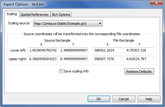
Scaling Source
Scaling information can be retrieved from multiple sources: Paper space (page units), all map frame names in the Surfer file, any coordinate system for each image in the Surfer file, and Saved settings. To select the appropriate map, click on the existing map name and select the desired map from the list. All objects are exported with the coordinates from the Scaling source.
Surfer provides potentially useful scaling info whenever possible. If a single Map is selected in the plot window, the map coordinate system is used for the Coordinate System. If a single image is selected in the plot window, the coordinate system for the image is used for the Coordinate System. If more than one Map object is selected, the Coordinate System is set to Paper space (page units). This can be changed to any of the Map coordinate systems in the list and all objects will be exported to this coordinate system.
If the application detects an unrotated 3-dimensional map object that is viewed from directly overhead (i.e., it is really a 2-D map object) and that map object is the only object being exported, it retrieves the (X,Y) data extents from the map and makes those the Scaling source. Otherwise, the application sets the Scaling source to Paper space (page units) so the coordinates will be the same as the document page units.
Paper Space
Paper space (page units) sets both the Source Rectangle and File Rectangle to page units.
Map Coordinates
Selecting any map or image from the Scaling source will load scaling info calculated by the application for the selected map or image.
Saved Settings
Saved settings will reload previously saved values.
Error | Exporting Rotated Maps (Map Units)
Applying transformations, such as Rotation or Shear, to a map object changes its orientation relative to the Cartesian grid of the page. Because most spatial file formats require standard Cartesian alignment, Surfer cannot generate accurate Map Units for rotated maps during export.
If a map is rotated or sheared, the Map Units option will be unavailable in the Export Options dialog, and the export will default to Page Space coordinates. This can cause the exported map to appear in the wrong geographic location (e.g., "ending up in Africa" due to page unit coordinates being read as lat/long).
To export a map using accurate Map Units, you must first remove the rotation:
-
In the Contents window, select the Map object.
-
Click the Home | Selection | Transform command to open the Transform dialog.
-
Check the Identity (Clear Transform) box.
-
Click OK.
-
The map will revert to its original unrotated state, and Map Units will be available during export.
Rectangle
Rectangle scaling is accomplished by specifying the corner points of a rectangle (in page units for the Source Rectangle) in the application document and the corner points of a rectangle (in Scaling source map units for File Rectangle). The document coordinates will be offset and/or scaled so the corner points of the document rectangle will have the desired coordinates.
The Page Rectangle lists two points on the page in the page coordinates. The File Rectangle lists the same two points on the page in the Scaling source coordinates.
Save Scaling Info
Check the box next to the Save scaling info option to save the scaling information to be stored for future use.
Defaults
Click the Restore Defaults button to set all options to default conditions. The scaling rectangles will, in turn, be reloaded with values from the default scaling source.