SEG P1 Import Options Dialog
The SEG-P1 Import Options dialog allows you to specify options which determine how information in the file is imported.
A SEG P1 file is a collection of point locations, usually used in geophysical shotpoints.
|
|
|
Specify the SP1 import options in the SEG-P1 Import Options dialog. |
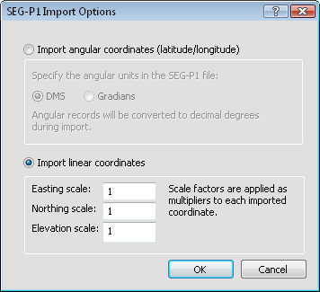
Coordinate Format
Select Import angular coordinates (latitude/longitude) if the data in the SP1 or SEG file is in latitude and longitude. Select Import linear coordinates if the data in the SP1 or SEG file is in a Cartesian coordinate system or an unknown linear coordinate system. Units can be in degrees, gradians, meters, feet, or any unknown units.
DMS or Gradians
When the Import angular coordinates (latitude/longitude) is selected, the Specify the angular units in the SEG-P1 file option becomes available. If the file contains degrees, minutes, and seconds, select DMS. If the file contains gradians, select Gradians.
Scale Factors
When the Import linear coordinates is selected, the Easting scale, Northing scale, and Elevation scale options are available. Highlight the existing value and type the new scale factor value in the box. Scale factors are multiplied by the values in the import file to get appropriate coordinates. This might be necessary if the Easting and Northing are in one set of units and the Elevation is in another set of units.
OK or Cancel
Click OK to continue importing the tabular SP1 data into a new table or the vector format SP1 file into a new base map. Click Cancel to quit importing the file.