Base (raster) Layer General Properties
Image files can be loaded into Surfer as a base (raster) layer with the Home | New Map | Base or Home | Add to Map | Layer | Base command. Click on the Base (raster) Layer object in the Contents window to open the base layer properties in the Properties window. If you wish to import the image without creating a map layer, use the Home | Insert | Graphic command instead.
|
|
|
The General page controls the image appearance and Spatial Extents. |
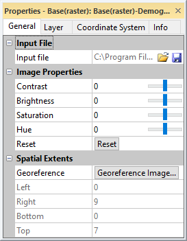
Input File
The Input File lists the current file used in the base map.
Change File
Click the  button to display the Import dialog. This allows you to select a new file or an updated version of the current file used to create the base map. If the file exceeds the current map limits, you will be prompted to adjust the map limits.
A raster file must be selected when changing the Input file for a base (raster) layer. An error message will be displayed if a vector file is selected in the Import dialog. If you wish to add a base (vector) layer to the map, select the Home | Add to Map | Layer | Base command instead.
Coordinate System Note
Regardless of the file selected with either the Map Tools | Reload | Map Data command or by clicking the button in the Properties window, the coordinate system for the original map layer is used after updating the file. If this is not the correct coordinate system, click on the map layer to select it. In the Properties window, click on the Coordinate System tab and set the coordinate system to the appropriate new system.
Save File
The  button displays the Export dialog. Type a File name and change the Save as type to the desired file format. Click Save. For some file types, a file type specific Export Options dialog appears. The Export Options dialog Spatial References and Scaling pages are available when saving a base layer. Check the desired file formats. It is recommend that GS Reference (Version 2) file option be checked to generate a .GSR2 file. Set any export options and click OK to save the file.
The georeference information is not saved for the image when exporting from the Properties window General page. To export the image in the map coordinate system, click the File | Export command and select Selected objects only option in the Export dialog.
Image Properties
The properties in the Image Properties section on the General page transform the image appearance: Opacity , Contrast , Brightness , Saturation , and Hue. These image transformations are applied to the display of the image or base layer, not to the image file. However, the image transformations are saved to the exported file when exporting the image or map.
Opacity
Change the Opacity of an image by entering a value from 0% (completely transparent) to 100% (completely opaque) or dragging the  to change the opacity percentage.
Contrast
Contrast is the difference in luminance or color of the objects in the image. Light and dark objects appear to stand out from one another when contrast is high. The difference in luminance between objects is difficult to see when contrast is low. The Contrast value is relative in Surfer. The original image is given a Contrast value of 0. Positive values increase the image contrast. Negative values decrease the image contrast. Type a value between -100 and 100 in the Contrast field or click and drag the to adjust the image contrast.
Brightness
Brightness is the perception of emitted or reflected light. Brightness can also be considered the average of the Red, Green, and Blue values for the pixels in the image. As brightness increases objects become lighter until they begin to "wash out" or turn white. Objects in the image get darker until they become black as brightness decreases. The Brightness value is relative in Surfer. The original image is given a Brightness value of 0. Positive values increase the image brightness. Negative values decrease the image brightness. Type a value between -100 and 100 in the Brightness field or click and drag the to adjust the image brightness.
Saturation
Saturation is a combination of light intensity and distribution across different wavelengths. High saturation relates to vivid, bright colors, i.e. high intensity across a narrow wavelength band or even single wavelength. This can also be considered very pure color. Low saturation leads to muted or gray colors, i.e. low intensity across a wide band of wavelengths. No saturation transforms the image to grayscale. The Saturation value is relative in Surfer. The original image is given a Saturation value of 0. Positive values increase the image saturation. Negative values decrease the image saturation. Type a value between -100 and 100 in the Saturation field or click and drag the to adjust the image saturation.
Hue
Hue describes the colors in the image. The Hue property shifts the colors in the image around the color wheel. The Hue value is relative in Surfer. The original image is given a Hue value of 0. Positive values shift the colors in the red to orange, then yellow, green, blue and finally magenta direction. Negative values shift colors in the opposite direction, from red to magenta then blue, green, yellow and finally orange. Type a value between -180 and 180 in the Hue field or click and drag the to adjust the image hue.
Reset
Click Reset to return the image to its original appearance. This sets Opacity to 100% and Contrast, Brightness, Saturation, and Hue to 0.
Georeference
Click Georeference Image in the Georeference field to apply control points to the image and reference it to your map's coordinate system. Clicking Georeference Image opens the Georeference Image window. The Georeference Image command is only available when the image is a base (raster) layer. The image must be at least 2x2 pixels to be georeferenced.
Spatial Extents
The Left, Right, Bottom, and Top values in the Spatial Extents group displays the current extents of the image. These values are read-only. Click the Georefence Image button to change the spatial extents.