Base Map
Base maps display geographic and political information such as roads, streams, lakes, or state and county boundaries. Base maps can be combined with any other map type in Surfer. A vector base map or raster base map is automatically created based on the input data.
|
|
|
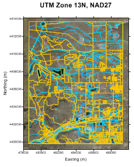
This map shows multiple base layers, depicting roads, waterways, and a USGS urban area satellite image for Golden, Colorado, USA. |
Base (vector) Layers
Base (vector) layers are created when a vector data file is used to create a base map. Vector files draw objects at precise X, Y locations on a map and can contain points, polygons, polylines, and text.
Symbology
Vector base maps can also include symbology. Symbology uses symbols or colors to display statistical information about the features in the base layer. Symbology applies line, fill, and/or symbol properties to features in the base layer depending on an attribute value. The symbology can be included in a legend. The type of symbology and the symbols' appearance are controlled in the Symbology dialog. Click Edit Symbology in the Base (vector) layer Properties window General page to open the Symbology dialog. These are the symbology types in Surfer:
- Unique Values - Line, fill, and/or symbol properties are specified for unique values in the attribute field.
- Unclassed Colors - Colors from a color spectrum are applied to the features by numeric attribute value.
- Unclassed Symbols - Symbols are added for each polygon feature and scaled proportionally by numeric attribute value, or point features are scaled by numeric attribute value. Unclassed Symbols symbology is not applied to polylines.
- Classed Colors - Colors are applied to the features by classifying numeric attribute values.
- Classed Symbols - Symbols are added for each polygon feature and classified by a numeric attribute value, or point features are classified by a numeric attribute value. Classed Symbols symbology is not applied to polylines.
- Pie Chart - Attributes in the base layer are added as Pie Chart symbols with classified pie slices.
Editing Features
Some base maps consist of multiple objects (i.e. polygons, polylines, text, etc.). The sub-objects can be selected individually in the Contents window and edited in the Properties window. The expansion state of sub-objects in the Contents window is retained in the Surfer .SRF file. Use the Expand new Contents window items option in the Options dialog to control the expansion state of new objects in Contents window.
Moving Features
Features such as points, polylines, and polygons can be moved between base (vector) layers and other base (vector) layers the plot document. The Move/Copy to Layer command can be used to move or copy features. Features can also be moved in the Contents window. To move a feature to another base (vector) layer, select the feature and drag it to a new position within another base (vector) layer. To move a feature to the plot document, select the feature and drag it to a new position above, between, or below the top-level objects in the Contents window.
Base Layers with Vector and Raster Data
When importing a file that includes both vector and raster data, such as with some DXF or GSI files, a base (vector) layer is created. In this case, the image properties are controlled by clicking the Image object in the Contents window.
Base (raster) Layers
Base (raster) layers are created when an image file is used to create a base map. An image file is a raster data file where the cell values correspond to pixel color. Rasters files where the cell values describe other information, such as elevation, are used to create grid-based maps. Some images files are georeferenced, where the image includes real world coordinates. Base (raster) layers can be georeferenced in Surfer.
Georeferencing is necessary to place unreferenced images in the correct relative position in the coordinate system. Occasionally you may need to adjust a georeferenced image. Georeference an image by selecting the base (raster) layer and clicking Map Tools | Layer Tools | Georeference Image. You can also right-click the base layer in the Contents window or plot window and click Georeference Image in the context menu. Finally, you can georeference a base (raster) layer by clicking Georeference image in the General page for the base (raster) layer. The image must be at least 2x2 pixels to be georeferenced.
If you need to add vector features to a map with a base (raster) layer, add an empty base layer to the map.
Creating Base Maps
There are four commands for creating new base maps:
- The Home | New Map | Base command or the
 button create base maps from existing vector or image files. Use the base map properties in the Properties window to set the base map line, fill, symbol, font, and opacity properties. With some images, you can also reassign the base map coordinates. You can also set the base map coordinate system.
 - The Home | New Map | Base | Base from Data command or the
 button create a base map from a data file. A data file containing XY data is used to create points in the base layer. Other data in the data file is added to the points as attribute data.
 - The Home | New Map | Base | Base from Server command or the
 button allows you to download an image or vector data as a base map from an online web mapping server.
 - The Home | New Map | Base | Empty Basemap command or the
 button create an empty base map with the intention of creating new geometry within the empty base map limits.
For example, the following steps are used to create a new base map from an existing file:
- Click the Home | New Map | Base command, click the Home | New Map | Base | Base from Data command, click the Home | New Map | Base | Base from Server command, or click the Home | New Map | Base | Empty Basemap command.
- Depending on which command was used, a dialog is respectively displayed.
- For the Base command, the Import dialog is displayed with a list of files in all the format types that can be imported. Select a file in the list and click the Open button. Sometimes an Import Options dialog for the file type is displayed. Make any changes to the import options and click OK.
- For the Base from Data command, the Base from XY Data dialog is displayed. Specify the rows to include and set the X and Y data columns. Click OK to create a base layer.
- For the Base from Server command, the Download Online Maps dialog is displayed. Select or add the server and layer, specify the area to download and resolution, and click OK to download the server base map.
- For the Empty Basemap command, the Base Map Limits dialog is displayed. Set the Minimum and Maximum X and Y values and click OK. A new empty base map is created.
The map is automatically created with reasonable defaults. Base maps are named with the name of the file from which the base map was created, such as Base(vector)-CentralCalifornia.gsi. New empty base maps are named Base. Base maps from servers are named with the map server name, such as Base(raster)-Orthoimagery/USGS_EDC_Ortho_NAIP or Base(vector)-Interstate. In addition, the image downloaded with the base map from server adds attribute information, including the server name and layer title.
Adding Base Layers
Select one of the four Add to Map base layer commands to add a base layer to an existing map:
- The Home | Add to Map | Layer | Base command adds a base map layer to the selected map.
- The Home | Add to Map | Layer | Base from Data command adds a base map layer from an XY data file to the selected map.
- The Home | Add to Map | Layer | Base from Server command allows you to add an image base map from an online web mapping server. When adding a base map layer from a server to an existing map with a defined coordinate system, the Specify Latitude/Longitude extents option is automatically selected. The boxes are filled in with the map limits of the current map.
- The Home | Add to Map | Layer | Empty Base command allows you to add an empty base map layer to an existing map.
Editing an Existing Base Map
To change the features of a base map, click once on the base map to select it. The properties are displayed in the Properties window.
Base (vector) Layer Properties
The vector base layer properties contains the following pages:
Individual objects in the vector base layer may have other pages, such as Line, Fill, or Text. Each object also has a Info page.
Base (raster) Layer Properties
The raster base layer properties contains the following pages:
Map Properties
The map properties contain the following pages:
See Also
Assigning Coordinates to an Image Base Map
Changing Properties in a Base Map