3D Digitize
The 3D View | Tools | 3D Digitize command allows you to write coordinates from a 3D view to the Digitized Coordinates dialog. Digitizing 3D coordinate data might be useful for identifying spot locations and writing their XYZ coordinates to a file. For example, these could be surface or subsurface points, such as 3D drillhole or borehole paths that you could later use to create a contour map to add to the drillhole 3D view.
Note: Use the Map Tools | Layer Tools | Digitize command to write 2D map coordinates from the 2D plot window to a data file. That digitizing tool is a good tool to digitize boundaries from maps and easily create a blanking file from the digitized information.
Digitized Coordinates Window
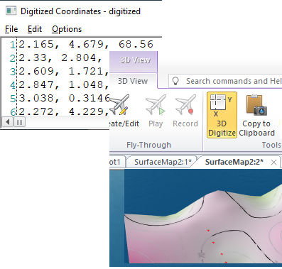
From a 3D view, click the 3D View | Tools | 3D Digitize command to enter into digitize mode. Left-click on a specific point over an object (e.g. surface, drillhole, or 3D geometry) in the 3D view, and the Digitized Coordinates window is displayed.
|
Digitized X, Y, and Z values are written to the Digitized Coordinates window. |
Each time the map is clicked, a small, temporary red symbol is drawn at the clicked location, and the XY and Z coordinates at the red symbol's location are written to the Digitized Coordinates window.
The Digitized Coordinates window stays open until it is closed by clicking the ![]() button in the top right corner of the Digitized Coordinates window. This allows convenient editing of the data and allows digitizing to start and stop multiple times and be recorded in the same window.
button in the top right corner of the Digitized Coordinates window. This allows convenient editing of the data and allows digitizing to start and stop multiple times and be recorded in the same window.
Note: For higher accuracy when digitizing 3D surfaces, increase the Surface quality property in the Surface Resolution section of the Surfaces General properties.
Menu Commands
The Digitized Coordinates window has three menus: File, Edit, and Options.
File
The File menu allows you to save or open a .DAT data file or a Golden Software Blanking .BLN file.
Edit
The Edit menu command allows for common editing, such as undo, redo, cut, copy, paste, delete, find, replace, and select all. These commands work in much the same way as the commands in the Home and Data tabs for a worksheet.
Options
The Options menu allows the user to set the numeric format with the Options | Coordinate Format command. This opens the Label Format dialog, where the numeric format can be set. The period is always used as the decimal separator. No prefix, suffix, or thousands comma can be displayed in the Digitized Coordinates window.
The Options menu also allows the user to specify whether the Z value is included when digitizing. Toggle the Options | Include Z coordinate command to include or not include Z values.
When digitizing to create a blanking file, the Options menu also determines if the digitized blanking file assigns the NoData value inside or outside the defined points. By default, the Options | NoData Inside Region option is checked. When saving the digitized coordinates, a 1 is written to the BLN file blanking flag, and the area inside polygons is assigned the NoData value. Click the NoData Inside Region option to change the setting. When NoData Inside Region is unchecked, a 0 is written to the BLN file blanking flag, and the region outside polygons is assigned the NoData value. By default, this setting is remembered during each Surfer session.
Digitizing Information from the 3D View
To digitize information from a 3D view, follow these steps:
- Create a 3D view and click the 3D View | Tools | 3D Digitize command. The cursor becomes a cross hair to indicate digitize mode.
- Click the left mouse button in the 3D view to write the current coordinates to the Digitized Coordinates window. Continue adding points in this manner. Digitized points appear as temporary small red 3D plus-signs on the 3D view.
- When you are finished digitizing points, click on any tool button or command or press the ESC key on the keyboard to exit digitize mode.
- To save the data in the Digitized Coordinates window, click the File | Save As command in the window. You are prompted to save the data as Blanking Files (*.bln) or Data Files (*.dat). Type a File name and click Save to save the data. Click Cancel to not save the data and return to the Digitized Coordinates window.
- Click the
 button in the top right corner of the window to close the Digitized Coordinates dialog. The dialog will stay open until closed in this manner.
See Also
Creating a Blanking File with the Digitize Command
