Esri Shapefile .SHP Export Options Dialog
The Export Options dialog, SHP Options page allows you to specify options which determine how information in the file is exported.
Attributes
All attributes for all polyline, polygon, and symbol objects are automatically exported to all .SHP files. For contour maps, the Z value is exported as the "ZLEVEL" attribute for all polylines in the contour map.
|
|
|
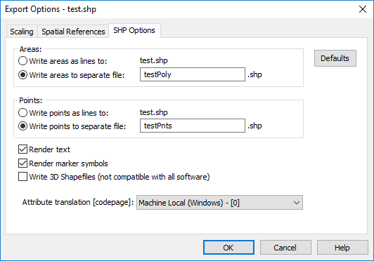
Specify the SHP file export options in the Export Options dialog. |
SHP Options Page
Note that an Esri Shapefile (.SHP) file may contain either line objects, area objects, or point objects, but not a combination of different object types.
Write Objects as Lines
All objects can be written as line objects. The Write areas as lines and Write points as lines options may be both selected, or either of the aforementioned controls may be selected individually, to write only the corresponding objects as lines. Alternatively, areas and/or points can be written to separate files by selecting the Write areas to separate file and/or Write points to separate file controls, in which case valid file name(s) must be typed into the adjacent edit control(s).
Render Text
Checking the Render text option renders the text objects as polygons, and saves the polygons to the file being exported. This is selected by default for SHP files and preserves the text content when exporting to formats that don't support text objects (e.g., SHP)
Render Marker Symbols
By default, marker symbols are output as points. Checking the Render marker symbols option instead converts the point symbols to polygons during export, preserving their shapes when exporting to formats that don’t support custom symbol definitions/indexes (e.g., SHP).
Write 3D Shapefiles
Check the Write 3D Shapefiles (not compatible with all software) check box to export contour lines and point, polyline, and polygon objects in a base layer as 3-dimensional objects, where each vertex for the point, polyline or polygon comprises an X, Y and Z coordinate.
-
When exporting a contour layer, the Z value of the contour line is used as the Z coordinate in the shapefile. The Z coordinate for each contour line is also stored as the ZLEVEL attribute in the DBF file.
-
When exporting objects in a base layer, the objects must have an attribute called ZLEVEL with the Z coordinate information. The ZLEVEL attribute is used as the Z coordinate in the shapefile, and all attributes (including ZLEVEL) are stored in the DBF file.
When Write 3D Shapefiles (not compatible with all software) is not checked, contour lines and objects in a base layer are exported as 2-dimensional objects, i.e. with X and Y coordinates only. When exporting a contour layer, the Z coordinate for each contour line is stored as the ZLEVEL attribute in the DBF file. For base layers, all attributes are exported to the DBF file.
You would export a contour layer as a 3D shapefile to import it into another software that can visualize this type of data, e.g. ArcScene. Not all software can read 3D shapefiles. Uncheck the Write 3D Shapefiles checkbox for maximum compatibility. In most cases, exporting the contours as a 2D shapefile with the Z coordinates in the DBF is sufficient.
Attribute Translation
By default, the "Machine Local (Windows)” code page (0) will be used to translate 16-bit Unicode attribute text to 8-bit ANSI text stored in the companion .DBF file. This can be changed by selecting a different code page from the drop down list. This code page will be stored in a companion .CPG file and also in the .DBF file header. If characters from multiple languages are present, consider selecting “UTF-8 - [65001]”.
Defaults
The Defaults button sets all options to default conditions.
Scaling Page
Scaling information can be set on the Scaling page.
Spatial References
The spatial reference information can be set on the Spatial References page. By default, if the map is in a defined coordinate system, the Esri .PRJ file is automatically created for this Esri file type.
See Also
Esri Shapefile File Description
Esri Shapefile Import Automation Options