Terrain Slope
The Grids | Calculate | Calculus terrain model, Terrain Slope, calculates the slope at any grid node on the surface. Terrain Slope is reported in degrees from zero (horizontal) to 90 (vertical). For a particular point on the surface, the Terrain Slope is based on the direction of steepest descent or ascent at that point (Terrain Aspect). This means that across the surface, the gradient direction can change. Grid files of the Terrain Slope can produce contour maps that show isolines of constant steepest slope. This operation is similar to the way the First Directional Derivative defines the slope at any point on the surface but is more powerful in that it automatically defines the gradient direction at each point on the map.
|
|
|
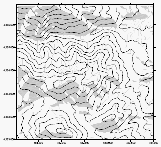
In this example, a contour map of the original DEM is overlaid with a terrain aspect map. South-facing slopes (between SE or 135° and SW or 215° ) are indicated with gray fills. Gray lines on north facing slopes are contour fills drawn where the aspect varies between 0 degrees (north) and 359 degrees (1 degree west of north). |
The slope, S, at a point P is the magnitude of the gradient at that point. From the definition of the gradient:
|
|

Using the compass-based grid notation difference equation yields:
|
|

The terrain slope is represented as a slope angle ST in degrees in keeping with the terrain modeling literature, such as Moore et al. (1993):
|
|
