Search
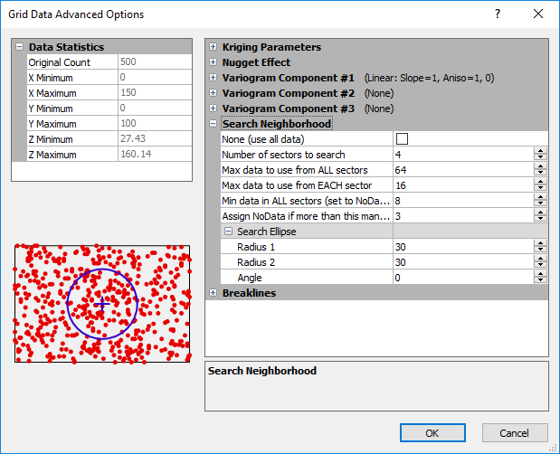
Search options control which data points are considered by the gridding operation when interpolating grid nodes. To access the search options, if available with the gridding method, click the Advanced Options button in the Grid Data dialog. If searching is available with the selected gridding method, a Search Neighborhood section appears in the Grid Data Advanced Options dialog. If search options are not available for a gridding method this means that all the data points from the data file must be used when calculating the grid.
Search Rules
Search rules define the number of points included in interpolating a grid node value. Clear the None (Use all data) option to enable the search rules edit controls. Search rules limit the number of data points to include in the interpolation at each grid node. Search rules work in concert with the Search Ellipse. The Search Ellipse specifies the size of the local neighborhood in which to look for data, and the search rules specify the number of points to actually consider within the neighborhood.
If the number of data points defined by the Min data in ALL sectors is not found within the Search Ellipse distance, the NoData value is assigned at the grid node. NoData values indicate that insufficient data existed to satisfy the search criteria at that particular location. Grid nodes assigned the NoData value truncate contour lines on contour maps, and produce low flat regions on wireframes.
Search Neighborhood
To access the search options, if available with the gridding method, click the Advanced Options button in the Grid Data dialog and expand the Search Neighborhood section of the Grid Data Advanced Options dialog.
|
|
|
Specify the search options for the selected gridding method in the Search Neighborhood section. |
No Search
The None (use all data) option tells Surfer to use all data when interpolating each grid node. Clear the None (use all data) box to activate the search during the gridding process. If the search is enabled, the following search options can be specified.
Number of Sectors to Search
The Number of sectors to search option divides the search area into smaller sections to which you can apply the following three search rules. You can specify up to 32 search sectors.
Maximum Number of Data to Use from ALL Sectors
The Max data to use from ALL sectors value limits the total number of points used when interpolating a grid node.
Maximum Number of Data to Use from EACH Sector
The Max data to use from EACH sector value specifies the maximum number of points to be used from each sector. Data points beyond the nearest points in a sector are ignored even if the data points in another sector are farther from the grid node being calculated.
Minimum Number of Data in All Sectors
The Min data in ALL sectors (set to NoData if fewer) value assures that the specified number of points are encountered when interpolating a grid node. If the minimum number of points is not found, the NoData value is assigned at the grid node.
Assign NoData to Node if More Than This Many Sectors are Empty
Assign NoData if more than this many sectors are empty assures that if more empty sectors than the specified value are encountered, the NoData value is assigned at the grid node.
Search Ellipse
Search ellipses are specified by defining the ellipse radii and the angle for the ellipse.
Radius 1 and 2
Radius 1 and Radius 2 are positive values indicating the distance in data units. The Radius 1 and Radius 2 values are the length that is searched in the direction indicated by the Angle. For all gridding methods except Nearest Neighbor and Modified Shepard's Method, the default values are calculated by taking half the distance of the diagonal.
Angle
Angle is the inclination between the positive X axis and the ellipse axis associated with Radius 1. This can be any value between -360 and +360 degrees.
