Setting Map Limits
Two methods exist for setting map limits. Map limits can be set in the plot window with the Set Limits command. The limits can be entered as values in the Properties window Limits page.
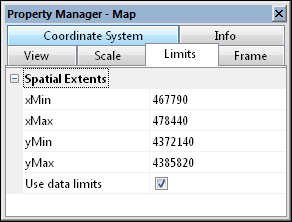
To set map limits on the Limits page:
-
Click once on the map object to select it.
-
The map properties appear in the Properties window.
-
On the Limits page, specify the X and Y minimum and maximum values for the map by entering the values into the xMin, xMax, yMin, and yMax boxes. The Use data limits check box resets the map limits to the limits of the grid file, base map, or posting data file limits.
-
The map is redrawn with the new limits. If the axes use automatic scaling, they are also redrawn to fit the new map limits.
|
|
|
Change map limits on the Limits page in the Properties window. |