Viewshed
The Home | Add to Map | Layer | Viewshed, the button, or Map Tools | Add to Map | Layer | Viewshed command adds a viewshed analysis layer to a map. The viewshed analysis indicates which grid cells are visible from an observer's, or transmitter's, location. Since the viewshed requires a grid and a transmitter location, the viewshed analysis must be added to a map object that already contains a 2D grid layer, i.e. contour, color relief, 1-grid vector, 2-grid vector, or watershed map. The current map layer provides a visual reference for placing the transmitter location.
|
|
|
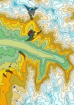
In this viewshed example, areas that are visible from the transmitter location are indicated with the partially transparent black fill. |
Add a Viewshed Layer
Viewsheds can only be created when the Map View Tilt is 90, the Map View Projection is set to Orthographic, and the map does not contain a 3D wireframe layer. If the map does not meet these settings, the Viewshed command will be grayed out. If your map does meet the requirements, follow the instructions below to add a Viewshed layer.
- Click the map object or map layer to which the viewshed will be added in the Contents.
- Click the Home | Add to Map | Layer | Viewshed or Map Tools | Add to Map | Layer | Viewshed command. The cursor changes to a cross-hair
 .
. - Click the desired transmitter location on the current map. Use the current map layer and the cursor location coordinates in the status bar to aid in transmitter location placement. The transmitter location can be refined or changed in the Properties window once the viewshed is created.
Viewsheds and 3D Surface Maps
Viewsheds can only be added to maps that are not tilted and in the orthographic projection. To temporarily change a 3D Surface map to this orientation,
- Click on the Map object in the Contents window.
- In the Properties window, click on the View tab.
- Change the Projection to Orthographic.
- Click and drag the Tilt (degrees)
 to 90.
 - Then, click the Home | Add to Map | Layer | Viewshed command.
Once the viewshed is located on the map, the Projection and Tilt (degrees) can be changed back to their previous values. Viewsheds cannot be added to 3D Wireframe maps.
Viewshed Properties
Once created, a viewshed can be modified with the properties in the Properties window. Click on the viewshed layer in the Contents window to view its properties in the Properties window. The viewshed properties contain the following pages:
Map Properties
The map properties contains the following pages: