Adobe Portable Document Format .PDF File Description
Portable Document Format, .PDF, is a file format used for document exchange. PDF is typically used for representing two-dimensional documents. Surfer can also export contours to 3D PDF documents. PDF was created by Adobe Systems.
File Structure
A .PDF file consists primarily of eight object types.
- Boolean values, representing true or false
- Numbers
- Strings
- Names
- Arrays, ordered collections of objects
- Dictionaries, collections of objects indexed by Names
- Streams, usually containing large amounts of data
- The Null object
Import
Click the Home | New Map | Base command to create a base map from a PDF file. Click the Home | Insert | Graphic command to import the PDF file as a group of objects or images. See PDF Import Options Dialog
GeoPDF
When a map with a defined coordinate system is exported to a Vector PDF file format, a GeoPDF file is created automatically. The scaling source for the GeoPDF is changed on the Scaling page in the Export Options dialog. When a map with a defined coordinate system is exported to a Raster PDF file format, the georeference options for the GeoPDF are changed on the Scaling and Spatial References pages in the Export Options dialog. The Internal file format option must be checked on the Spatial References page to create the GeoPDF.
An add-on, such as TerraGo toolbar, may be needed to view the GeoPDF options in Adobe's Acrobat or PDF Reader programs. The map layer and map must have an assigned coordinate system in Surfer prior to the export.
GeoPDF files can be imported as a base map in Surfer.
Export PDF
Surfer offers multiple ways to export your work to a PDF, with File | Save | Save as PDF being the most direct and convenient. This option is recommended because it simplifies the Save as type list to just PDF, which is quicker than selecting it from the extensive list in the File | Export dialog. Printing to PDF is not recommended as it may remove print properties for subsequent jobs.
For exporting 3D content, Surfer provides two options for exporting 3D PDFs: Export 3D Contour Maps lets you export contour maps in 3D format, while Export 3D View of Model exports the currently displayed layers of the 3D model in the 3D View to a PDF document. More detailed information about both methods can be found in the following sections
An add-on, such as TerraGo toolbar, may be needed to view the GeoPDF options in Adobe's Acrobat or PDF Reader programs. The map layer and map must have an assigned coordinate system in Surfer prior to the export.
To create a GeoPDF file, which can be re-imported as a base map, ensure the map layer has an assigned coordinate system. You may need an add-on like the TerraGo toolbar to view these georeferenced features in a PDF reader.
Export 3D Contour Maps
This method allows you to export contour maps as 3D PDFs, where only the contour lines are rendered as a 3D model inside a PDF document. It is best suited for maps containing only contour layers with consistent XYZ units. To use this option, follow the instructions below.
-
Open your file and set your maps coordinate system, the PDF will only be in map units if the map has a coordinate system defined for it
-
Uncheck the axes in the Contents window since the PDF will draw the Z value at zero and not at your Z settings.
-
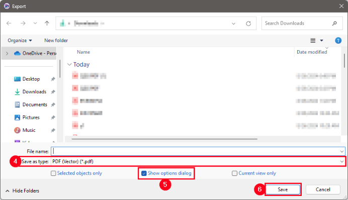
Click on File | Export.
-
In the Export window click the drop-down for Save as type and select PDF (Vector) (*.PDF) file.
-
In the Export window make sure the Show options dialog check box is selected.
-
Click Save.
-
In the Export options window select the Vector PDF Options tab.
-
In the 3D PDF options section select the first checkbox, Write vector graphics as embedded 3D models.
-
Change any other options on the tab as desired.
-
Click OK.
Export 3D View of Model
This method exports the layers of the 3D model currently displayed in the 3D View to a PDF document. The entire model is exported, including contours, volume renders, 2D grid surfaces, isosurfaces, and more. The resulting PDF allows for interactive features such as rotating, zooming, and toggling layers on and off. Note that if you export the 3D view, that includes a volume render, to a 3D PDF, the volume render is displayed as a series of slices. To use this option, follow the instructions below.
-
Open your file, right click your map and select 3D View.
-
Click on 3D View | Output | Export 3D.
-
In the Export 3D window select your save file name and location, and click Save.
-
In the Export Options dialog set your desired settings for your file.
-
Click OK.
See Also
Adobe Acrobat .PDF Export Automation Options
Adobe Acrobat .PDF Import Automation Options
Adobe Acrobat PDF Import Options Dialog
Adobe Acrobat .PDF Raster Export Options Dialog