Changing Map Coordinates
Next, we are going to adjust the units used to display the map by changing the coordinate system.Surfer automatically converts source data from different coordinate systems into the coordinate system specified by the Map frame. In this case, we'll change the map target coordinate system from WGS1984 to State Plane 1983 (feet).
Before we can change the coordinate system for the map, we must first make sure the source coordinate system is defined for each map layer. The source coordinate system defines the system used to create the layers dataset and is required to change the map coordinates. In this case, both the post and contour layer were created using the same dataset with WGS1984 latitude and longitude coordinates.
If you completed the assign coordinates steps from the Data Best Practices lesson, both your map layers will already have the WGS84 coordinate system assigned. Steps 1-12 in this exercise will still be useful when working with other datasets such as images, vector files, and grids from other sources.
- Click the Contours layer in the Contents window.
- Click the Coordinate System tab in the Properties window.
If the source coordinate system has any other name, this means that Surfer read the coordinate system information automatically. We do not recommend changing the source coordinate system for a map layer if it is already set.
- Click Set in the Coordinate system field.
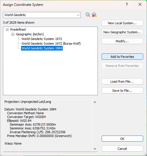
- Use the search bar at the top of the Assign Coordinate System dialog to locate the World Geodetic System 1984 coordinate system in the structured list. Select World Geodetic System 1984.
|
- Click OK.
You can also set the same coordinate system to all unreferenced layers by assigning the appropriate coordinate system to the Map frame first. This saves time when you have several unreferenced map layers that were all created using the same source coordinate system. We'll complete those steps next so you can see how it's done.
- Select the Map frame in the Contents window. For this action, it is not recommended to click in the plot window to select the Map frame.
- Click the Coordinate System tab in the Properties window.
- Click Change in the Coordinate system field.
- Click World Geodetic System 1984 under Favorites or use the search bar at the top of the Assign Coordinate System dialog to locate and select the World Geodetic System 1984 coordinate system in the structured list.
- Click OK.
- Click OK in the Surfer Warning dialog.
- In the Properties window, click Assign Now next to Assign to unreferenced layers.
Now that all of the map layers have the correct source coordinate system assigned, we can change the target coordinate system to any system we desire. In this case, we're going to choose State Plane 1983 so that the X, Y, and Z coordinates all use the same units (feet).
- Select the Map frame in the Contents window.
- Click the Coordinate System tab in the Properties window.
- Click Change in the Coordinate system field.
- Use the search bar at the top of the Assign Coordinate System dialog to locate and select the State Plane 1983 - Oregon South FIPS 3602 (US feet) coordinate system in the structured list.
- Click OK.
The final step in our map making journey will be to adjust the scale of the map so that it's easy to read on paper. To do this:
- Verify the Map is still selected in the Contents window.
- Click the Scale tab in the Properties window.
- Check the box next to Proportional XY scaling.
- In the X Scale sction, enter 80000 in the Map units per in. field.
- If needed, click and drag the Scale Bar to the desired position.
And with that last adjustment we have a finished map!
|
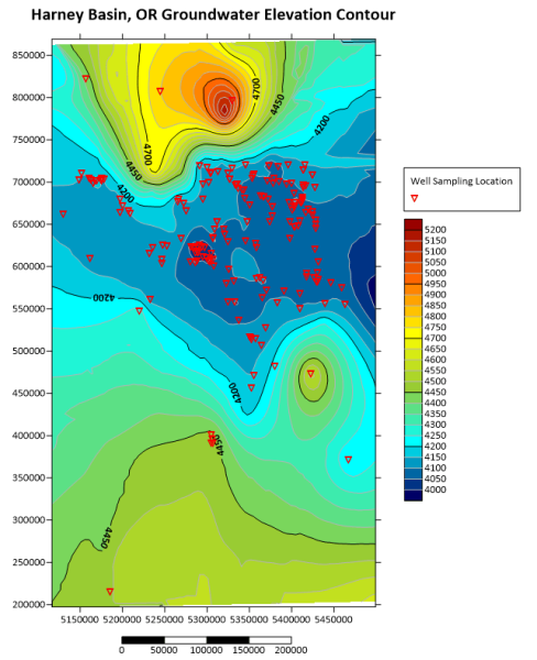
| The map is now displayed using the State Plane 1983 - Oregon South coordinate system. |
You have now been introduced to all of the steps needed to create stunning maps with Surfer. The same process can be used to create maps with different types of data and different map layer types allowing you to create almost any map you can imagine.
Now that we have a finished map, we can explore it in 3D and share our results.
Back to Adding Context Layers
Next to Viewing Maps in 3D