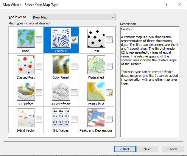
Map Wizard - Select Your Map Type
Click the Home | Wizard | Map Wizard command to open the Map Wizard. The second page is the Select Your Map Type page. Here you select the layer types you would like to create in your map and whether to create a new map or add the layers to an existing map. Click Next to proceed to the Select Gridding Parameters or click Finish to create your map. Which button is displayed depends on your selections in the Select Your Data and Select Your Map Type pages.
|
|
|
Specify the layer types you wish to create and select whether to create a new map or add the layer(s) to an existing map. |
Add Layer To
The Add layer to option determines if the new map layer or layers will be added to a new map or an existing map. A new map is created by default. Select [New Map] to create a new map in the plot document. Alternatively, click the Add layer to field and select an existing map from the list to add the layers to an existing map.
Map Types
Select the desired layer types by clicking the map type. A check mark indicates a map layer will be included. Click on a selected layer type to clear the check box. A lock indicates the map type is not compatible with the source file selected on the Select Your Data page.
-
Data files (including LiDAR data files) can be used to create any of the map layer types: Base, Contour, Post, Classed Post, Color Relief, 3D Surface, 3D Wireframe, Watershed, 1-Grid Vector, and Grid Values.
-
Grid files can be used to create the grid-based map layers: Contour, Color Relief, 3D Surface, 3D Wireframe, Watershed, 1-Grid Vector, Peaks and Depressions, and Grid Values.
-
LiDAR data files can be used to create the Point Cloud map layer. Select Point Cloud from the LiDAR Load Options dialog that appears after selecting a LiDAR data file.
-
Boundary files can only be used to create a Base map. Try the Home | New Map | Base command to quickly create base maps without the Map Wizard.
The 3D wireframe layer type cannot be overlaid with a 3D surface or color relief layer. When a new selection cannot overlay with a previous selection, the previous selection is cleared.
Creating Grid Based Maps from Data Files
When a data file is selected on the Select Your Data page and a grid-based layer is selected on the Select Your Map Type page, a grid must be created before creating the map. The Finish button changes to Next. Click Next to proceed to the Select Gridding Parameters page and create the grid.
When the data source is a grid file or boundary file, the map can be created by clicking Finish.
Description
The Description section includes a brief explanation of the map type, as well as which data types are used to create the layer type and any conflicts with other layer types.
Back, Finish, Next, or Cancel
Click Back to return to the Select Your Data page if you wish to change the data source. Click Finish to create your map. When gridding is necessary, click Next to proceed to the Select Gridding Parameters page. Click Cancel to close the Map Wizard without creating a map.
