3D Wireframe
Wireframes are three-dimensional representations of a grid file. Wireframes are created by connecting grid node values along lines of constant X and Y. Each XY intersection occurs at a grid node and the height of the wireframe is proportional to the value assigned to that node. The number of columns and rows in the grid file determines the number of X and Y lines drawn on the wireframe.
|
|
|
This wireframe displays gradationally colored lines that show elevation. The intersections of the lines occur at grid nodes. |
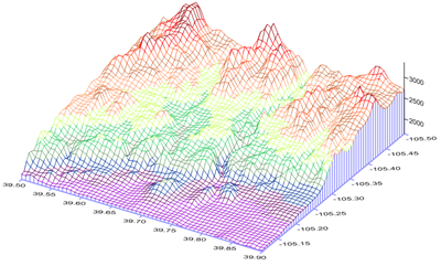
Wireframes can display any combination of X lines, Y lines, or contour lines. When a 2D grid is loaded the contour lines are lines of constant Z values. When a 3D grid files is loaded, the contours are lines of constant C for the selected Z slice. On the wireframe, X lines correspond to the columns in the grid file and Y lines correspond to rows in the grid file.
The grid limits define the extent of the wireframe. When creating a grid file, set the grid limits to the desired limits for the wireframe. The wireframe cannot be larger or smaller than the extent of the grid file. Use the Grids | Resize | Extract or Grids | Resize | Mosaic commands to produce a subset or to thin a grid file. Use Grid | Spline Smooth to increase the density of a grid file in order to add additional X and Y lines to the wireframe. Use the Grid | Data command to create a new grid file with different limits.
Creating a 3D Wireframe
- Click on the Home | New Map | 3D Surface | 3D Wireframe command or the
 button.
 - Select a grid file in the Open Grid dialog and click Open.
-
If the selected file is in a format that supports 3D grids (e.g. VTK, HDF) the Data Type dialog will be displayed.
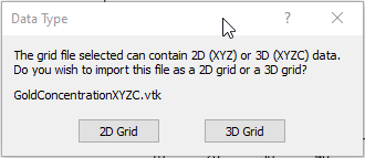
Click 2D Grid to import XYZ data or click 3D Grid to import an XYZC lattice with slice controls. If 2D grid is selected for a 3D grid file, the bottom slice (lowest Z value) will be imported.
The map is automatically created with reasonable defaults.
Editing an Existing 3D Wireframe
To change the features of the 3D wireframe map, click once on the wireframe map in the plot window or in the Contents window to select it. The properties are displayed in the Properties window.
Adding a Map Layer
When wireframe maps are created, they are independent of other maps in the plot window. For example, creating a wireframe map while a contour map is present in the plot window yields two separate maps, each with its own set of axes and scaling parameters. To create a single map with the contour map on the wireframe map, select both maps by clicking the Home | Selection | Select All command. Overlay the maps using the Overlay Maps command.
Alternatively, you can add the contour map directly to the existing wireframe map by creating the contour map using the Home | Add to Map | Layer | Contour command. This automatically adds the contour map to the existing wireframe map axes.
Another alternative is to create both maps using the Home | New Map commands. Then, select one map and drag the map layer to the other map object. This is equivalent to using the Overlay Maps command to overlay maps. For example, create a contour map with the Home | New Map | Contour command. Create the wireframe map using the Home | New Map | 3D Surface | Wireframe command. This creates two separate maps. Click on the contour map, hold down the left mouse button, and drag the contour map into the wireframe map. A single map with two map layers, using one set of axes and scaling parameters is created.
Wireframes cannot be overlaid with other wireframes, point cloud layers, or on raster-based maps such as 3D surfaces, color relief maps, and base (raster) layers. Wireframes can be overlaid with contour maps and other map types.
Wireframe Layer Properties
The wireframe properties contains the following pages:
Map Properties
The map properties dialog contains the following pages: