3D Surface
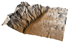
The Home | New Map | 3D Surface command can be used to create a three-dimensional shaded rendering from a grid file. You can also click the Home | New Map | 3D Surface | 3D Surface command to create a 3D surface. The height of the surface corresponds to the value of the associated grid node. Denser grids show greater detail on the surface.
Color can be used to further illustrate surface values. The colors are blended to form a smooth gradation. Once the color is selected, the lighting can be adjusted, changing the appearance of the map.
|
|
|
This 3D surface map is displayed with custom colors and no axes. Customize your map to display exactly the map you want. |
Creating a 3D Surface
To create a 3D surface:
- Click on the Home | New Map | 3D Surface command or the
 button.
 - Select a grid file in the Open Grid dialog and click Open.
-
If the selected file is in a format that supports 3D grids (e.g. VTK, HDF) the Data Type dialog will be displayed.
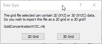
Click 2D Grid to import XYZ data or click 3D Grid to import an XYZC lattice with slice controls. If 2D grid is selected for a 3D grid file, the bottom slice (lowest Z value) will be imported.
The map is automatically created with reasonable defaults.
Editing an Existing 3D Surface
To change the features of the 3D surface map, click once on the surface map in the plot window or in the Contents window to select it. The properties are displayed in the Properties window.
Adding a Map Layer
When surface maps are created, they are independent of other maps in the plot window. For example, creating a surface map while a contour map is present in the plot window yields two separate maps, each with its own set of axes and scaling parameters. To create a single map with the contour map on the surface map, select both maps by clicking the Home | Selection | Select All command. Overlay the maps using the Overlay Maps command.
Alternatively, you can add the contour map directly to the existing surface map by creating the contour map using the Home | Add to Map | Layer | Contour or Map Tools | Add to Map | Layer | Contour command. This automatically adds the contour layer to the existing surface map axes.
Another alternative, is to create both maps using the Home | New Map commands. Then, select one map and drag the map layer to the other map object. This is equivalent to using the Overlay Maps command to overlay maps. For example, create a contour map with the Home | New Map | Contour command. Create the surface map using the Home | New Map | 3D Surface command. This creates two separate maps. Click on the contour map, hold down the left mouse button, and drag the contour map into the surface map. A single map with two map layers, using one set of axes and scaling parameters is created.
Surface maps can be layered with images, vector files, and other 3D surfaces. You can overlay other map types, with the exception of 3D wireframes, on a surface. 3D surface maps can be created independently of other maps, or can be combined with other maps in map layers. Surfaces can be scaled, limited (clipped), or moved in the same way as other types of maps.
If there are map layers on a 3D surface, and the surface is made invisible through the Contents window, the layers will not be visible.
Overlaying Coincident 3D Surfaces
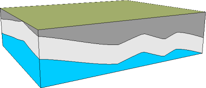
Multiple coincident 3D surfaces can be overlaid. The bases can be displayed by checking Show base on the Properties window General page to create a block diagram. Control which base color is displayed by arranging the 3D surface layers in the Contents window. The 3D surface layer that is to be drawn first should be placed at the bottom of the Map object in the Contents window. The 3D surface that should be drawn last should be placed highest in the Map object. Vary the base fill colors to represent different layers in the block diagram.
|
|
|
This is an example of multiple overlaid 3D surface layers with different color bases. |
3D Surface Tips
- Image base maps, i.e. base (raster) layers, can be added to surface maps if both maps contain the same coordinate ranges. You may need to change the image coordinates so the maps use the same coordinates.
- Two or more 3D surface maps can be overlaid with one another. This is useful if you want to join two adjacent surface maps. Alternatively, you can use Grids | Resize | Mosaic to create one grid.
- Surface maps do not have a source coordinate system. All maps that are overlaid onto a surface map must have the same coordinates.
3D Surface Layer Properties
The surface properties contains the following pages:
Map Properties
The map properties contains the following pages: