Color Relief Map
Color relief maps are raster maps based on grid files. These maps represent grid values (most commonly elevations) with user specified colors. NoData regions on color relief maps are shown as a separate color. Hill shading or reflectance can be enabled to enhance contrast and visualization.
|
|
|
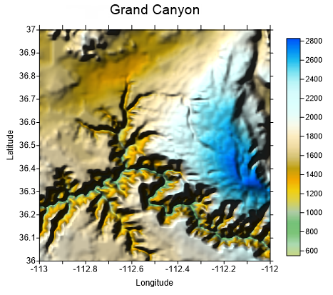
This hill shaded color relief map shows the Grand Canyon. Colors show elevation in the area. |
A colormap is used to map grid node values to specific colors. Surfer automatically blends colors to produce a smooth color gradation over the map. 16 million colors are available (true color definition), creating smooth color variations.
The color schemes for color relief maps can be saved in Color Spectrum .CLR files. With such a file, the colors defined for one color relief map can be used with any other color relief map. Since the colors are stored as a percentage of the grid data range, a single color spectrum file can be used for multiple maps, even if the associated grid files cover significantly different data ranges.
Creating a Color Relief Map
To create a color relief map:
- Click the Home
| New Map | Color Relief command or use the
 button.
 - Select a grid file in the Open Grid dialog and click Open.
-
If the selected file is in a format that supports 3D grids (e.g. VTK, HDF) the Data Type dialog will be displayed.
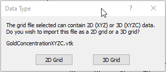
Click 2D Grid to import XYZ data or click 3D Grid to import an XYZC lattice with slice controls. If 2D grid is selected for a 3D grid file, the bottom slice (lowest Z value) will be imported.
The map is automatically created.
Editing an Existing Color Relief Map
To change the features of the color relief map, click once on the color relief layer in the plot window or in the Contents window to select it. The properties are displayed in the Properties window.
Adding a Map Layer
When color relief maps are created, they are independent of other maps in the plot window. For example, creating a color relief map while a contour map is present in the plot window yields two separate maps, each with its own set of axes and scaling parameters. To create a single map with the color relief layer on the contour layer, select both maps by clicking the Select All command. Overlay the maps using the Overlay Maps command.
Alternatively, you can add the color relief map directly to the existing contour map by creating the color relief map using the Home | Add to Map | Layer | Color Relief or Map Tools | Add to Map | Layer | Color Relief command. This automatically adds the color relief layer to the contour map axes.
Another alternative, is to create both maps using the Home | New Map commands. Then, select one map and drag the map layer to the other map object. This is equivalent to using the Overlay Maps command to overlay maps. For example, create a contour map with the Home | New Map | Contour command. Create the color relief map using the Home | New Map | Color Relief command. This creates two separate maps. Click on the color relief map, hold down the left mouse button, and drag the color relief map into the contour map. A single map with two map layers, using one set of axes and scaling parameters is created.
Color relief maps cannot be added as a map layer to 3D wireframe maps, but a color relief map can be added to any other map layer, including 3D surface maps.
Color Relief Layer and the 3D View
When the map in the 3D view contains a reflectance color relief layer, the 3D view Lighting is applied to the already shaded reflectance map. The cumulative effect of both lighting systems can result in very dark regions of the map in the 3D view.
To brighten the results, change the Ambient color from Black to a lighter color in the Lighting tab of the Properties window for the 3D View Environment
Color Relief Layer Properties
The color relief layer properties contains the following pages:
Map Properties
The map properties contains the following pages: